#5G #3D mapping. The REAL #Big #Brother.
“Engineers from University Alliance Ruhr have developed novel signal processing methods for imaging and material characterisation with the aid of radar. Their long-term objective is to use these techniques in combination with radar-based localisation of objects. Their vision is a flying platform capable of generating a three-dimensional representation of its surroundings. The technology might be, for example, useful for finding out what firefighters might encounter behind clouds of smoke in a burning building.”
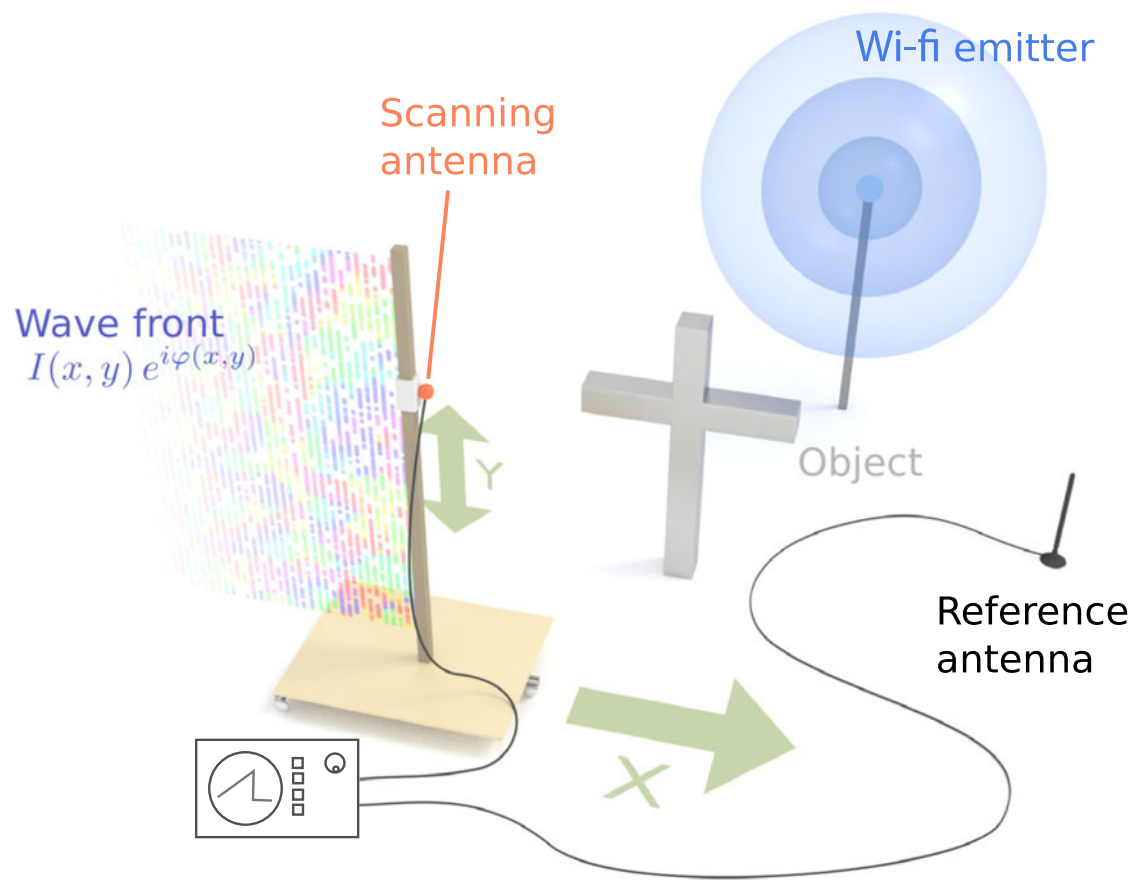
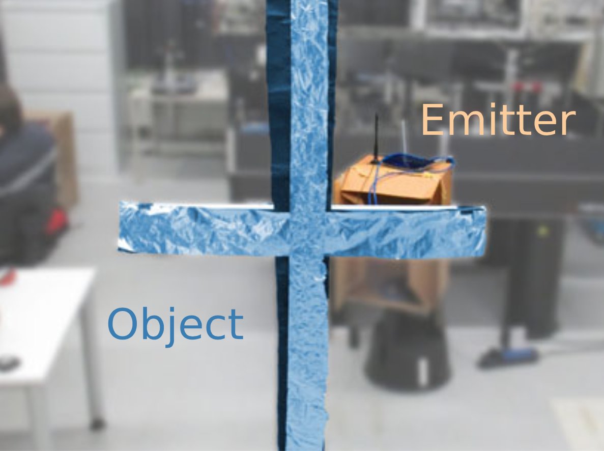
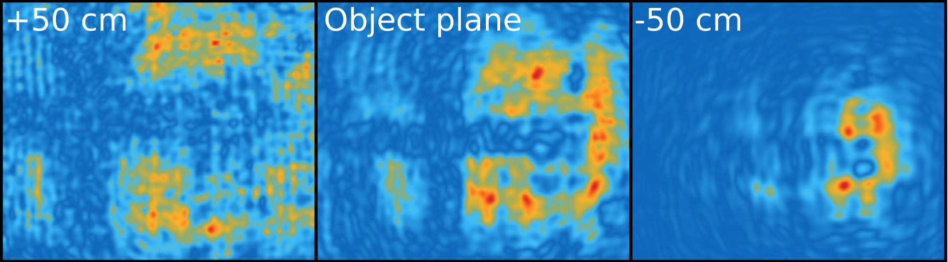
“Wireless data transmission systems such as wi-fi or Bluetooth emit coherent light—electromagnetic waves with a precisely known amplitude and phase. Propagating in space, this radiation forms a hologram—a two-dimensional wave front encoding a three-dimensional view of all objects traversed by the light beam. Here we demonstrate a scheme to record this hologram in a phase-coherent fashion across a meter-sized imaging region. We recover three-dimensional views of objects and emitters by feeding the resulting data into digital reconstruction algorithms. Employing a digital implementation of dark-field propagation to suppress multipath reflection, we significantly enhance the quality of the resulting images. We numerically simulate the hologram of a 10-m-sized building, finding that both localization of emitters and 3D tomography of absorptive objects could be feasible by this technique.”
Visualisation below proves what RF and WIFI can be used for: DARPA is also developing new visualization tools for SC2 to enable analysis and commentary on CIRNperformance. For the first time ever, these tools make it possible to comprehend the RF spectrum and complex behaviors such as how the CIRNs are using the radio spectrum and how they interfere with each other. Researchers can quickly scrub back and forth through time in RF scenarios while focusing on different 3D views of the radios and their interactions both spatially and in the RF spectrum. The visualizations also provide a valuable way for spectators of the SC2 competition to understand what is happening so they can engage with the new CIRN technology.

An associate: https://www.saveusnow.org.uk has been #gagged by the #Police and his #Council for trying to blow the lid on what’s happening in his #County. What he is witnessing is literally a weapons test to see what happens when #5G is installed in communities. Results: #Bleeding noses. #Cot #deaths. #Womb #deaths. NO #sleep. #Brain #Cancer. #Tumours. And if you take down the #5G relays on top of streetlights #POLICE will appear with engineers and you will be taken to #Court.
This is the big one people. Hold tight for an Action Pack to fight 5G in your area. We’re testing through Freedom of Information requests #FOI and other legal forms to produce something that works.
#EMF #Radiation
PDF references:
smombie-gate-Wi-Fi can be used to photograph rooms through walls – Business Insider
smombie-gate-3-D mapping of rooms using radar — ScienceDaily
smombie-gate-PhysRevLett.118.183901